

Lulworth Cove - One of the most beautiful parts of the Dorset Coast and a very popular visiting area by sailing yachts. Pilotage into the cove is not difficult but there are hazards for the unwary, so have a pilotage plan for visiting. (N50º 37.092′ W002º 14.865′)
The importance of Passage and Pilotage Planning. Don't leave 'Home' without it!
'Home' in this case being your departure port. This may be where your boat is generally moored up or indeed a port en-route between your home port and your destination.
Not having a plan for the next stage of your voyage could be a recipe for disaster.
Passage and pilotage complete we can confidently start our voyage from the Hamble River, into the Solent en-route to the English Channel and our destination, Brixham in Devon, England. (N50º 50.100′ W001º 18.520′)
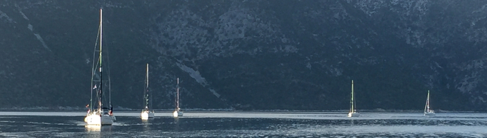
Take the above image of Lulworth Cove on the coast of Dorset, England. This is a beautiful mooring, particularly for yachts who call in for a lunch stop or simply to experience the tranquility of the cove. It is an easy trip from Weymouth or Portland marinas or indeed from the east of the English Channel en-route to these destinations. It looks so easy and comfortable to enter. However entry and exit pilotage will be necessary and tidal conditions could be significantly different if your stay is for a few hours. Probably the first thing is to collect information from, for instance, 'Reeds
Nautical Almanac' ('The Bible') for the area and/or a publication such as Tom Cunliffe's, 'The Shell Channel Pilot'. We would advise that 'Reeds' should be considered an essential pilotage and passage planning tool and always kept on board. For those navigating between The South Coast of England and the North Coast of France, 'The Shell Channel Pilot' is also essential and packed with invaluable passage planning and pilotage detail. A quick read will tell you the difficulty in spotting the cove from seaward. Keep east of centre on entry. Make a quick sketch of the cove using one of out Pilotage Planning Forms, it doesn't need to be to scale. Include tide details at entry and assumed exit times, check the depth contours and suitable anchorage - it isn't as big as it looks. Weather and wind conditions are important - don't go in if the wind is blowing hard from the SW - it will be most uncomfortable. Check the gunnery range times! Note the area of rubble and submerged bricks in the SW corner - do not anchor near this area. This cove is popular and can be busy. Take care not to drop anchor and rode other other yacht's chains. Holding can be poor. All this detail and more can be quickly gained from the Pilot and Almanac. All these important pieces of information need to be written down whilst on passage particularly if the detour to the cove was not part of the original plan. The main thing it that not so doing can result in unexpected consequences. Many sailors think that coastal sailing is less risky than ocean or channel passages. Not so! Coastal sailing can contain many more hazards to be dealt with, or avoided, and requires adequate passage planning to cope with whatever comes our way. Pilotage Planning Forms, Passage Planning Forms, Port of Refuge Planning Forms and Tide Detail Forms offer a way to make it easy to quickly write these details down in a logical manner to make a robust pillotage plan in short order. Furthermore, once safely departed from the cove, the details can be easily erased and the forms ready to be used for the next pilotage.

Entering 'The Bag' moorings near the Devon town of Salcombe. Heading for the visitors pontoon on the flood tide.(N50º 14.558′ W003º 45.546′)
Althouth the above example is
coast location exactly the same pilotage throughout the World. Port area will be covered by a sailing, whether it be within the

Weighing anchor following a visit to Scabbacombe Sands, on Passage to Salcombe, Devon. (N50º 21.420' W003º 31.193′)
given of an idyllic UK, southern
procedure would be used for Just about every coastline and Pilot guide, essential for safe UK, Mediterranian, Carribean,

Spartahori, Meganisi, Greece (N38° 39.719' E20° 45.691'). A beautiful overnight stop for yachts cruising the Ionian Sea. But beware! Close to the entrance of the bay is the Heiromiti Reef (N38° 41.109' E20° 45.523'). Submerged and not always marked, it claims a few yachts each year. This needs to be shown on your Passage/Pilotage plan.
or any of the World sailing areas. Many have hidden challenges which require accurate passage/pilotage planning, the absence of which could result in undesired consequences. Always remember that 'my passage plan' is probably the most important document I have on board. Don't leave 'home' without it!
End note - although we recommend the publications mentioned above, we have no affiliation with either 'Reeds Almanac', 'The Shell Channel Pilot', or Imray publishers.
Postage Info. Q & A Privacy Policy Terms & Conditions of Sale
Contact us Join our Mailing List
![]()
Passage Planners is the brand name of www.passageplanning-sales.com
© 2016-2025 PassagePlanning-sales.com