
True Heading, (T°) Variation (V°) Magnetic Heading (M°) Compass Deviation (D°) and Compass Course (C°)
Navigating a sailing yacht or any other marine vessel involves initial preparation such as Passage Planning, Pilotage and Port of Refuge planning. These subjects are covered in detail in other parts of our website and can be accessed by clicking on the tabs at the top ribbon of this page.
The data which you develop for your Passage Plans will generally be based on details taken from the maritime chart(s) relative to your voyage.
However, prior to or leaving port on your passage you will need to convert the headings shown on your plans from True Headings to Compass Headings otherwise you will not arrive at the positions detailed on your plans.
Why?
Because the headings drawn on your passage plans, if taken from marine charts, will most likely be True Headings. If you use your compass to follow a True Heading between say, two waypoints, it is most likely that that you will not achieve the position of the second waypoint.
This is because your compass is being affected by two magnetic effects which need to be accounted for in order to achieve a Compass course which will enable you to follow your required course. These are as follows:
True Heading (T°).
T° = True Heading: There are many ‘definitions’ of this and sometimes it appears to be somewhat complicated.
We consider that True Heading Tº is determined by the direction of your boat to the geographic north pole (also called true north). It is the heading we wish to sail after taking into consideration the effects of Magnetic Variation (V), and Compass Deviation (D).
Maritime charts refer to the geographical poles only. Thus if you draw a line on a maritime chart from one point to another, then the measurement of degrees is the angle measured in a clockwise direction from the north line to the line drawn in order to give the True Heading Tº.
Magnetic Variation (V°).
V° = Magnetic Variation:
Maritime charts grids align with true north, however setting a boat’s course is not just a matter of steering in relation to the north pole. This is because magnetic compasses point to the earth’s magnetic poles which can be somewhat different to the geographic north pole. Magnetic Variation can be very large in certain parts of the World, e.g South of Africa it is approx. 32° (West). At the time of writing this article (March 2024) the Magnetic Variation off the shores of the UK South and West Country is small and ranges between 0º 47′ West to 01º 29′ East. However, in the Mediterranian Sea it is approx. between 2º East and 5º East.
The magnetic poles move around with time and only very rarely line up with the earth’s geographic poles.
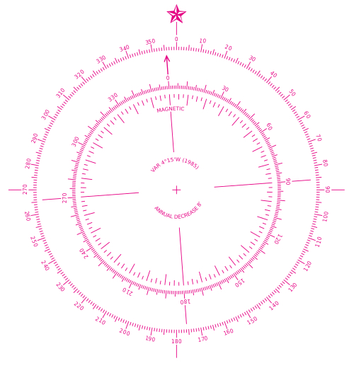
Maritime charts include at least one compass rose. It is a figure on a nautical chart used to display the orientation of the cardinal directions (north, east, south, and west) and their intermediate points. Thus, the differential of angle between True North and Magnetic North is displayed, together with the measurement date and the annual movement, from which one can calculate the approximate position as at the current year. The difference between True north and Magnetic North is called Magnetic Variation. It is sometimes called magnetic declination (just to make it more complicated).
We will continue to call it Magnetic Variation!
Setting a course to steer is affected by
Compass Rose: Var 4º 15′ W (1985). Annual Decrease is 8′. Thus: Decrease from 1985 to 2024 = 39 years x 8º = 312′ ÷ 60 = 5º 12’.
So Var 4º 15′ W (1985) becomes Var 0º 57′ E ( 2024)
a further issue known as Deviation which is
discussed below.
Rather than go into greater detail of how to calculate Variation, we refer you to an excellent Link on how to calculate Magnetic Variation from a Maritime Chart.
Please note that the link will open in a separate Tab. (Please note that leaving ths page will take you ouside of our site privacy policy).
https://www.linkedin.com/pulse/how-calculate-variation-nautical-chart-explained-deck-eduard-marin
The Link relates to two examples of Magnetic Variation which may be calculated from the data given. Noting that the article was written during Year 2019, we reckon that the answers are:
1. 2° 55’ W
2. 0° 38’ W
Let us know if you don’t agree?
More about Compass Roses:
Most maritime charts will contain more than on and sometimes several compass roses.
For instance looking at our (Imray C10) Western English Channel chart, we note that there are three compass roses.
Which one should we use? This would be the rose nearest the area in which we are sailing. If we are making a longer passage we would need to take into account the rose nearest to the area we are subsequently on passage. If we are on a much longer passage we would, at some time need to adjust for the rose nearest to our extended passage. Thus, if I was on passage between, say Southampton and Isles of Scilly, we would be using all three of the roses on the chart. All of the three roses show Variations measured in Year 2014. The first one (1) shows Variation 1° 35’ W (2014) Decreasing about 9’ annually. The second (2) shows Variation 2° 10’ W (2014) also Decreasing about 9’ annually and the third (3) shows Variation 2° 40’ W (2014) also Decreasing about 9’ annually.
Thus, assuming we are making a Variation calculation in Year 2014 we would have the following Variations:
(1) V = 1° 35′ W less 10 (years) decreasing X 9′ = 1° 35′ W - 1° 30′ = 0° 5′ W
(2) V = 2° 10′ W less 10 (years) decreasing X 9′ = 2° 10′ W - 1° 30′ = 0° 40′ W
(3) V = 2° 40′ W less 10 (years) decreasing X 9′ = 2° 40′ W - 1° 30′ = 1° 10′ W
For practical use this would be rounded up or down to the nearest whole degree. So the variations to use in 2024 is:
(1) 1° W (2) 1° W (3) 1° W
Not much really, however on a long passage as described above of some 242 nautical miles this could lead to a significant course error of over 4 nautical miles if ignored.
Note: OK our Imray chart is somewhat old. However we do keep it up to date using Imray updates!
Magnetic Heading (M°).
M° = Magnetic Heading
This is the compass heading after taking into consideration the True Heading T° and the effects of Magnetic Variation V°.
Thus if the True Heading T° is 260° and the Magnetic Variation V° is 1° W then the Magnetic Heading M° will be 261°. i.e if Magnetic Variation (V°) is West then
M° = T° + V°
However if the True Heading T° is 260° and the Magnetic Variation is 1°E then the True Heading T° will be 259° i.e if Magnetic Variation (V) is East then
M° = T° - V°
Magnetic Deviation (D°).
Compass Deviation = D°
Compass deviation is a magnetic error effecting the steering compass. This is a magnetic interference unique to the vessel itself.
The term ‘deviation’ is used to describe the effect of interference from magnetic fields created by the vessel’s own equipment. This can be from things such as chart plotters, VHF radios, speakers, batteries, large metal objects like the engine etc. It is almost certain that your compass will be affected by such outside interference and this will affect your Compass Course (C°) if not taken into account.
The overall effect of the vessels deviation can be calculated. In order to find the compass deviation you need to “Swing your boat compass”.
It is recorded on something called a deviation card. Details of how to “Swing your boat compass” and make a deviation card can be viewed Here. (opens in a new tab)
NOTE: As with chart variation, if the Deviation noted from the deviation card at the Magnetic heading M° is shown as °W (West) then the deviation is added. If the Deviation is shown as °E (East) then the deviation is subtracted. If you have not made a deviation card you won't be able to accurately adjust for Deviation which can be quite significant at some bearings. It is to be recommended that a deviation card be produced as detailed above. It isn't difficult and will give you the confidence that you have all of the corrections to hand when subsequently calculating the Compass Course (C°).
Compass Course (C°).
Compass Course = C°
Thus the Compass Course to steer is the Magnetic Heading (M°) + Compass Deviation (D°) in order to achieve the required True Heading (T°).
_______________________________
We have tried to make this important navigation subject as simple as possible. During our research we looked at the myriad descriptions to be seen on websites, many of which we considered to be overly complicated.
We hope that we have described these navigation terms in an easy to absorb way. If we have failed, we apologise. It is not a difficult subject, however trying to simplify it and still make sense is not so easy! Please let us know if we have succeeded (or otherwise)!
Leeway and Navigation
The above article attempts to make clear the important navigation subject regarding the various Courses necesssary for effectice navigation at sea.
There is an additional aspect which should also be taken into account when underway. This is Leeway and its effect on Compass Course (C°). We have treated it as a subject which should be read in addition to the above article. You can access it by clicking Here which will take you to our article called Navigation with Leeway. (opens in a new Tab).
SO - CAN WE HELP FURTHER??
Recognising that this is such an important subject to sailors we have developed an Excel application entitled “PASSAGE PLANNERS - COMPASS HEADINGS AND CALCULATIONS”
In writing our Excel app. we covered two main items as follows:
Sheet 1 entitled “Definition” describes in detail the following: True Heading (T°), Variation (V°), MagneticHeading (M°), Compass Deviation (D°) and Compass Course (C°).
Additionally it includes 2 worked examples using Variation and Deviation as W° values and also when Variation and Deviation values are E°.
We believe that this makes for a very clear, simple and concise understanding of the subject.
Sheet 2 entitled “Calculate” is an Excel application which uses macros to help it work. The application can be used for calculations at your planning stage and/or as you travel on your passage in order to calculate your Compass Course (C°) for your current passage plan leg. Or, by knowing your current Compass Course (C°) you will be able to automatically calculate your True Heading (T°).
You will, of course be already aware of your Chart Variation and Compass Deviation (for the Magnetic Heading from your compass deviation card).
The sheet also enables you to record previous calculations for Compass Course (C°) and True Heading (T°).
Sheet 3 entitled “Records”
The sheet is an extension of Sheet 2 allowing further recording of previous calculations for Compass Course (C°) and True Heading (T°) calculated in Sheet 2..
Prior to having a look at our Excel App. Compass Headings and Calculations Click Here (opens in a new tab) to have a look at an example of how we used it during a recent voyage from Corfu in the Ionain Sea, to the Island of Rhodes in the South Aegean Sea, a distance of approx. 565 n. miles.
Click Here to see and purchase: our Excel Application
“PASSAGE PLANNERS - COMPASS HEADINGS AND CALCULATIONS”
NOTE: This Excel application was written using: Microsoft Excel for Mac
Version 16.82 (24021116). License: Office Home & Student 2021.
It uses Macros which must be accepted for the application to work. We guarantee that this Excel Application and macros is totally free from anything which will harm your computer.
Copyright of Compass Rose gratefully acknowledged as belonging to Wikipedia.
Postage Info. Q & A Privacy Policy Terms & Conditions of Sale
Contact us Join our Mailing List
![]()
Passage Planners is the brand name of www.passageplanning-sales.com
© 2016-2025 PassagePlanning-sales.com