


Buy Tidal Stream Calculation Form
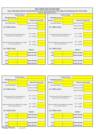
Tidal Stream Calculation Form
The objective of this form is to calculate the tidal stream start and end times for particular parts of the coast along the Passage Plan Route, such as headlands and other areas along the route where we wish to take advantage of favourable streams, or indeed avoid headlands with unfavourable streams. This is of particular interest to sailing yacht skippers whose knowledge of streams throughout the passage can make the difference between a pleasant voyage or an uncomfortable one, particularly when the passage time exceeds more than one tidal period.
One side of the sheet allows you to enter data for your chosen area from a tidal stream atlas and tide tables for the high water reference port.
Ref: TS1
NOTE: An Excel program can be downloaded for free which will do the same job for you. Click here for more details. (Opens in new tab)
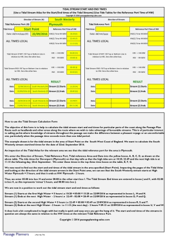
The reverse side gives full details of how to use the form, by going through a detailed calculation for a particular area.
The form is heat encapsulated within a premium matt plastic A4 size pouch which allows for data to be written using a B grade black pencil. Details may be altered as required by erasing and re-entering. There is plenty of space on each line to allow easy entering of detail. Use several times.
Ref: TS2
Click to link to our Tides link page which will allow you to get Reference Port tide times for free. Page will open in a new tab.
Click to link to Tidal Stream Data for UK areas to enable you to determine start/end times of tidal streams for your selected areas. Page will open in new tab on a website not connected to passageplanning-sales.com.
Passage Planners
A form to help you calculate tidal stream data along your passage plan route.
Postage Info. Q & A Privacy Policy Terms & Conditions of Sale
Contact us Join our Mailing List
![]()
Passage Planners is the brand name of www.passageplanning-sales.com
© 2016-2025 PassagePlanning-sales.com