
🇧🇪 🇫🇷 🇬🇧 🇩🇪 🇺🇦
How to Write and Prepare a Safe Rock Solid Passage, Pilotage and Port of Refuge Plan
Practical examples of the use of our Passage and Pilotage planning forms including tuition for planning a sea voyage.
Sample Passage and Pilotage Plans - Passage planning for longer voyages - Passage Planning Appraisal, Planning, Execution and Monitoring help. An introduction to Passage Planning
Passage planning is fundamental to a safe voyage from what is known as 'dock to dock', that is from your departure dock to your arrival dock. In order to demonstrate with a tutorial on how to write a passage plan and offer some guidance and tuition on how our passage planning forms can guide you in preparing a passage plan, we are detailing two different passage plans and pilotage examples to help you. We will presently be detailing an additional passage and pilotage plan between Peel, Isle of Man and Portaferry near Strangford, N. Ireland. This is a difficult passage & pilotage, requiring accurate planning, and depends on good weather and fair tides for the access and pilotage through Strangford Narrows. We will defer this until a suitable time during 2025 presents itself. Please be aware that, although the navigation details in the following examples were correct at the time of publication; weather, tidal and navigation changes mean they may not be applicable now, and so they are not to be used for navigation purposes. Their relevance is for passage planning and pilotage planning tuition only. For the purposes of this exercise and to avoid any confusion, a passage plan and a sailing plan have the same meaning. A sailing plan is based generally on the same criteria as any passage plan, and in effect sailing plans and passage plans are one and the same.
RYA Day Skipper, Yacht Master, Coastal Skipper and Ocean Master Courses.
Our Passage Planning forms are designed to help with the shore based navigation and practical parts of the above RYA courses and also for the other Navigation and Seamanship courses including online courses run by the RYA. They provide a detailed form for accurate navigation planning.
Our Passage Planning products are also suitable for professional maritime training courses.
When we start to plan a voyage, whether it be along our coastline or an offshore passage we follow the same basic principles of passage and pilotage planning to collect data and information related to our voyage When we have this, we use the data to draw our route on relevant charts, and use our laminated planning forms for the writing of our plans. If we are planning a passage over a longer period of days or weeks we will need to take into account the essential need to adequately victualling our yacht with the necessary food, drinking water and other vital stores required for a safe voyage. We have written a separate article on victualling a sailing yacht including a very detailed victualling list and a unique Victualling/Provisioning app, both of which can be downloaded for free. Our victualling article and downloads can be viewed HERE (opens in a separate tab).
The four principles of voyage planning used by us are as follows.
1. APPRAISAL
Having decided our departure and arrival port or harbour we need to gather all the required information and detail to make a safe passage in between. This is also a risk assessment for the critical areas we may pass though and will include the pilotage relating to our departure, arrival and suitable refuge ports in the event of an en-route problem requiring us to divert to another safety port, tidal gates and port cill and/or flap gate opening times. We will be taking information from charts, tide tables, tidal atlas, nautical almanacs, pilot publications, notices to mariners, buoyage detail and position, navigation warnings, areas to be avoided, depth/height restrictions, reporting requirements, weather and sea condition forecasts, and our own experience of the sailing area. Almanacs and charts need to be current and are required to be kept up to date. All major chart suppliers such as Imray and Admiralty have links to their update pages for this to be carried out. From our own experience in the UK, the use of and information contained in our current Reeds Nautical Almanac is invaluable for extracting much of the data required. A relevant Pilot book for the sailing area is another essential source. Online advice relating to your proposed sailing area and port entry pilotage can be obtained from Port Authorities, marinas, sailing clubs and many other sources; but remember that it is your responsibility to check the veracity and relevance of such advice. Should you be carrying crew it is important that they are sufficiently experienced for the voyage ahead. The weakest link in, particularly long passages, can be the crew, and the skipper needs to select and be able to have confidence in their abilities for such voyages.
3. EXECUTION
Following the planning stage, it now needs to be carried out in accordance with your original planning. However, between the planning stage and the time to set sail, various things may have changed and so it is important to check various factors. You can now enter the final details mentioned at the close of 2 Planning. We would suggest a check be made of the following:
- Harbourmasters notices for departure and destination harbours.
- Weather conditions - need to be checked over a period prior to departure (say 12 hr. and 2 hr. prior and also for the expected period of passage. Expectation of wind and rain conditions may, for instance, affect your planned start time and passage time. Monitoring the weather throughout the passage is required to be undertaken at regular intervals.
- Sea conditions - tidal conditions for the period throughout the passage need to be monitored. These include possible tidal streams and the tide height may constrain or determine your departure and arrival time. Re-check any tidal gates you expect to encounter during the passage. Also ensure that any harbour entrance cills or flap gates will be down at the start and end of your passage.
- Day/night sailing needs to be anticipated depending upon your departure time and length of passage. Assuming that you, the skipper are experienced at night sailing, your crew may not be, so it is important that you have the confidence that your crew will cope with these conditions under your leadership. Remember that everything looks very different in the dark and the myriad lights on entering a port can be intimidating and confusing.
- Should the passage be fairly long there will be a requirement to have good watchkeeping procedures in place. Your crew will be required to take part in the watchkeeping rota and will need to know how to keep watch, and know what to look for on passage. Our Watchkeeping forms can be viewed here.
- It is important for the crew to be made aware of your Passage Plan and of the intentions of you, the skipper. This will help give them confidence, especially during long passages.- Local warnings of navigation hazards along the route need to be checked via Coastguard / Harbourmaster publication. Checks include for instance, navigation buoy light which may not be functioning, coastal firing practice etc.
- Be prepared to alter your plan in the event of the details checked above. Almost any plan needs to be revised when conditions and events are encountered at sea. Our forms are designed to make such revisions quickly and easily.
2. PLANNING
This is here we start to use the data gathered and to write it down to make a workable passage and pilotage plan.
We would begin by taking the relevant chart(s) covering our proposed sailing area and, in pencil, mark waypoints on the chart along our proposed route from leaving our moorings to reaching our destination point. The waypoints need to be chosen with care in order to avoid any danger areas as found during our apppraisal stage, and to follow advice obtained from our research. When satisfied, the waypoints will be joined up to give us our route over ground. When we are satisfied, each waypoint will be numbered and each leg arrowed for direction and a distance (Nm) and bearing (ºT) marked in pencil for each leg. We would then look very carefully at the proposed route with particular reference to buoyage and other navigation restraints in order to be satisfied that our route is safe to follow and at a suitable distance from perceived dangers.
We use our laminated forms to help with this. Our initial pilotage to leave our port or harbour will be written on form Reference: PLA12.
Our passage planning forms can be seen at Reference: PPA12.
Our Port of Refuge forms can be seen at Reference: PR12
Our Wire bound planning books can be seen HERE.
Until we know the date when we are to make our passage, we can't enter detail such as tide detail, date, springs or neaps tide condition, tidal stream, weather forecast, or cill/harbour gate opening times.
4. MONITORING
Once underway you will need to keep a continuous check of your actual progress in comparison to your passage plan. This will be generally checked by position fixing. If you have a chart plotter on board it is likely that you will have entered your waypoints and route prior to leaving your moorings. This will be your primary means of checking your position - but what if it fails? Your Passage Plan should contain, where possible, bearings to coastal features for relevant waypoints and by use of a hand bearing compass these can be used to check your position. This should be practiced on a regular basis even having a fully operational chart plotter on board. It is also a good exercise for crew members to practice and will give them confidence. Another method to find your approximate position is to use a three point fix (known as a cocked hat position fix). Needless to say, all your navigation equipment should be accurate, in good working condition, and always be ready for use.
- A radio check is essential at the start of your passage. In the UK this will usually be made with the coastguard on radio channel 16.
- Each time your position check is made, the time and position needs to be recorded in your logbook and also on the relevant chart, which will also have your route and waypoints marked, as detailed in the planning stage of your passage.
- Depth monitoring is essential throughout your passage and pilotage, from your departure to your destination. This will generally be relayed from your boat’s echo sounding equipment. However, should this fail, a hand lead line is your only choice and should be carried with your boat’s equipment.
- All your findings and notes need to be recorded in your logbook including weather monitoring, which should be made on a regular basis, together with any relevant weather forecast radio information from coastguard or other sources.
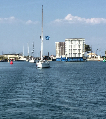
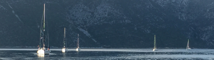
PHOTO - On passage from Vonista, Greece to Spartahori, Meganisi, Ionian Sea, Greece. The passage includes the Lefkas Canal which is very shallow in places requiring good depth monitoring throughout. Arrival time at the swing bridge at the top of the canal (see blue/white structure top right of photo) is important due to restricted
opening times. Yacht traffic can be very dense at busy times. A great experience though! Note the direction of buoyage. This changes direction a little further south, just before the entry to the Ionian Sea. (N38º 50.597′ E20º 43.052’)
Example 1 - Plymouth to Fowey
Shown below are scans of the details of a passage and pilotage plan from Plymouth to Fowey, Cornwall. We started our planning by gathering the related information relating to our proposed voyage (known as passage planning appraisal) and then pencil drawing our proposed route on to our Imray charts covering the area from Start Point to the Fowey River (Imray 2004.7, 2004.8, 2400.13). Figures 1 and 2 detail the pilotage plan from the Queen Anne's Battery marina to the Draystone Buoy to the south east of Penlee Point. This required us to make two pilotage plans and one passage plan. The Plymouth pilotage passes through a very busy area, this being a naval base with the possibility of heavy traffic. The tidal data for the day was entered in the pilotage and a time of 09:00 was chosen for a fair tide out of Plymouth Sound. Other details were entered (see plans), wind, expected weather, sea state as suitable for the pilotage and the relevant waypoints were entered on the initial pilotage plan after a route had been drawn on the Imray chart (2400.13). Other pilotage details were taken from Reeds Almanac and a sketch made as Fig.2. Various bearings were noted in order to help fix our waypoints and the various beacons, buoys and other details were entered in the notes, thus having a record of what we expected to see along the pilotage. We were expecting a speed of 5kt. throughout the journey, and this enabled us to work out the timings between waypoints. Note: Click on the plans to zoom detail.


Figure 1:Pilotage Plymouth


Figure 2:Pilotage sketch Plymouth Figure 3:Passage Plan Draystone to Fowey
All of our notes and sketches were easily drawn in pencil on our pilotage planning forms which are matt plastic heat encapsulated pouches suitable for writing on with a tough waterproof surface.
Our passage plan took us from the Draystone Buoy, to the south of Rame Head, across Whitsand Bay to south of the Udder Rock cardinal buoy and hence to the entrance of the Fowey River. At this point we commenced the pilotage plan for the last part of the voyage. Figures 3 and 4 record the waypoints and coastal route and notes the leg trip distances for the complete passage and pilotage plans, thus giving us estimated times for the start and end of each leg of the passage. Various instructional notes are detailed on Fig. 4 for each of the passage plan legs.


Figure 4: Passage Plan Sketch Figure 5: Pilotage Fowey

Figure 6: Pilotage Fowey Sketch
Pilotage Fowey River
Our second pilotage plan Figures 5 and 6, started at a point on the centre line of the river and in line with St. Catherine's Point on the east shore and the Punch Cross pile beacon on the west shore. The Fowey pilotage is not difficult in good sea and weather conditions, however it can be a very busy port and a good lookout is required. Our intended mooring was near Penleath Point and, as there was no visitors pontoon at that time of year, we expected to call the harbour patrol early for instruction. Communication details were
entered on our pilotage form, including lights and marks; pilotage and navigation remarks were taken from Reeds Almanac for the area.
Additional notes for Pilotage
- Use transits during pilotage, they are everywhere and are both natural and chartered features which are useful to aid you.
- Always have your depth gauge calibrated and with the correct offset.
- The use of chartered depth contours are able to provide good position lines.
- Be aware of your calculated tide heights.
- When on pilotage, ask yourself what actions you would take if your visibility became restricted by fog?
- Make sure that you sketch your pilotage plan rather than rely on only a list.
- Always keep your crew fully informed of your actions, and whenever possible, engage them to help. This will give them good experience and confidence.
Example 2 - Totnes to Dittisham
An entirely different pilotage was made from the head of the River Dart at Totnes, down to Dittisham moorings, to the north of Dartmouth. The route, through the most beautiful scenery along the river, is very tidal as it passes through the upper reaches of the river. The route needs to be navigated during the flood, and the passage meanders across the river where the main navigation channel routes between large areas of shallow mud. Although reasonably buoyed, it is essential to fully concentrate during the passage to avoid grounding in the silt.
Due to a late flood we were not able to leave the Baltic Wharf at Totnes until 18:15, approximately one hour before high tide. The stream against us was slight. Weather and wind conditions were very good and by following a detailed sketch on our Passage Planner of our desired route and using the relevant Imray chart combined with our Reeds Almanac detail, we were able to calculate our bearings, trip distances and times for the passage. Additionally we checked each leg with our expected buoyage and other navigational marks along the route. We were well aware that, as it was a calm and pleasant evening, we could expect to see rowers on the river from the local rowing clubs. Once confident with our route detail, we transfered the waypoints to our chart plotter. Our passage down the river was made using both our passage planning forms and chart plotter. It was a beautiful one hour voyage and, yes, sure enough we passed several rowing teams returning up river.
Whilst on the passage, one of our crew filmed some of the beautiful scenery along the way. A clip is shown at the end of this article. Note the proximity of the route to the bank of the River Dart.


Figure 7: Route weather & tide detail. Figure 8: Passage plan sketch, time/distance trip Figure 9: Details for each Passage leg
Click on images to zoom


Figures 10-12: Continuation forms containing details for each Passage leg
Click on images to zoom
Below: A short video taken during the passage detailed in the above Passage Plan. (N50º 24.591′ W003º 38.569′)
Finally
In using our encapsulated passage planning forms as a template, we have presented the above passage planning and pilotage planning tuition as a practical example of the use of our passage planning forms. The example shown is taken from a real passage carried out previously. We included a lot of data in producing this passage plan guideline, particularly regarding the Plymouth pilotage which was via a busy channel out through the south west of Plymouth Sound. In carrying out your own planning you may include less or indeed more data depending on your knowledge of the area. The forms are designed partly as an aide memoir for the most salient features to be included in a good passage plan but also for you to include or indeed restrict information as you feel fit. We didn't include a port of refuge in our example because, between the two ports there really isn't a suitable bolt hole.
_______________________
Local Day Sailing - strategy
Often the day sailing we do will start and end at the same port, generally our home port. However, we are still required to carry out a passage planning excercise even though the trip may only be down the coast or around the bay, returning a little while later. We still need to be aware of, and plan for the weather and tides for the period away from our mooring. We still need a plan as to where we are going, whether we want to anchor for, say lunch or a swim, perhaps we may be returning in the evening, thus requiring additional knowledge regarding navigation, lights and other things we take for granted during day sails. We need to know that, should we need to use our engine, we have sufficient fuel on board for our journey. If we have crew and or passengers on board with limited sailing experience, we are required to plan for these limitations and, indeed we will need to make all those on board aware of the safety equipment and procedures available including having sufficient provisions such as food and water for the day. Bearing in mind that it is generally colder on the sea than in port, always check that any crew and passengers have waterproof and warm clothing with them, including sun protection cream for day use.
How we personally deal with this is to have a 'generic' pilotage and passage plan sketch for our local area. It includes 'no go' areas such as close to shores, rocks, shallows, reefs, shoals and other areas we need or are required by Harbour masters notices and suchlike to avoid. We include clearing lines on the sketch to help with 'no-go'areas. Each time we leave port we check that the generic sketch is still relevant. Additionally we update tidal, weather, safety detail, fuel levels and any other item which we consider relevant to the day sail. We also find it useful to check current issues of the local Harbour Master Notice for the local sailing area. Such notices advise sailors of current warnings relating to activities and suchlike within the area covered by the local harbour. Such advice can be used to avoid, for instance, a local sailing race which we would wish to avoid sailing through. Our laminated passage and pilotage forms are designed such that all this detail can be quickly and easily entered. Changeable details such as tide, weather, wind and other such variations can be erased at the end of the day for re- entry prior to the next local sail.
All other longer passages are planned by making a new passage plan and pilotage plan for our intended port. Any port of refuge along the passage is dealt with by completing a port of refuge plan for each relevant port.

Photo left - The beautiful port of Gaios located on the east coast of the island of Paxos, south of Corfu. This area of the Ionian Sea in Greece is virtually without tides. Nevertheless this does not obviate the need for good passage planning and accurate pilotage planning, as the port is not simple to enter, particularly in windy conditions. Great care needs to be taken to ensure that the shallow areas are avoided in navigating this lovely part of the coast.
(N39º 11.800′ E20º 11.200′)
End note - although we recommend the publications mentioned in the above examples, we have no affiliation with either 'Reeds Almanac', 'The Shell Channel Pilot' or Imray publishers.
Postage Info. Q & A Privacy Policy Terms & Conditions of Sale
Contact us Join our Mailing List
![]()
Passage Planners is the brand name of www.passageplanning-sales.com
© 2016-2025 PassagePlanning-sales.com